Archivo:Jakarta Skyline Part 2.jpg


|
Copyright warning: A subject in this image is protected by copyright.
This image features an architectural or artistic work, photographed from a public space in Indonesia. There are no freedom of panorama exceptions of any kind under the Chapter VI (Copyright Limitations), Articles 43–51 of the Indonesian Copyright Act No. 28, 2014, which means that these architectural or artistic works cannot be photographed freely for anything other than non-commercial or personal uses. If a copyrighted architectural or artistic work is contained in this image and it is a substantial reproduction, this photo cannot be licensed under a free license, and will be deleted. Framing this image to focus on the copyrighted work is also a copyright violation. Before reusing this content, ensure that you have the right to do so. You are solely responsible for ensuring that you do not infringe someone else's copyrights. See our general disclaimer for more information. |

Resumen
| Descripción |
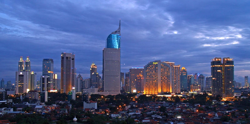
English: Lining up Jakarta's skyscrapers along the CBD with Wisma 46 as the centerpiece.
Wisma 46 is designed by Zeidler Partnership and has been well-known for being Indonesia's tallest building; and Jakarta's most distinguished skyscrapers with its unique shape resembling an elegant fountain pen. Singapore may have a "Durian" (The Esplanade); and Beijing has a "Bird's Nest" (Olympic Stadium) and "Trousers Pants" (CCTV Tower); but Jakarta has an elegant "Fountain Pen". Although it may not be the tallest building in Indonesia now, -with the completion of Menara BCA and The Kempinski Residences at the Grand Indonesia Mall complex; and construction at The Jakarta Tower (558m) is coming soon-, Wisma 46 remains one of the nation's most distinguished and unique building. |
| Fecha | |
| Fuente | https://www.flickr.com/photos/joe-joe/2303992129/ |
| Autor | yohanes budiyanto |
| Ubicación del objeto | | Ubicación de esta y otras imágenes en: OpenStreetMap |
|---|
Licencia
- Eres libre:
- de compartir – de copiar, distribuir y transmitir el trabajo
- de remezclar – de adaptar el trabajo
- Bajo las siguientes condiciones:
- atribución – Debes otorgar el crédito correspondiente, proporcionar un enlace a la licencia e indicar si realizaste algún cambio. Puedes hacerlo de cualquier manera razonable pero no de manera que sugiera que el licenciante te respalda a ti o al uso que hagas del trabajo.
| Esta imagen fue publicada en Flickr por yohanes budiyanto en https://www.flickr.com/photos/27228523@N00/2303992129. La imagen fue revisada el 20 de diciembre de 2009 por el robot FlickreviewR y confirmó tener licencia bajo los términos de cc-by-2.0. |
Historial del archivo
Haz clic sobre una fecha/hora para ver el archivo a esa fecha.
| Fecha y hora | Miniatura | Dimensiones | Usuario | Comentario | |
|---|---|---|---|---|---|
| actual | 21:45 3 may 2023 | | 1546 × 768 (801 KB) | B18IDH | Maybe This Is More Correct? |
Usos del archivo
La siguiente página enlaza a este archivo:
